What you thought you knew about Tennessee’s caves, rivers, borders and more
Although Tennessee History for Kids’ focus is history (obviously), the organization also tries to help teachers teach Tennessee geography.
For the early grades, this means concepts like Tennessee’s three Grand Divisions, four principal cities and three main river systems. For the older students, this has required me to dig a bit deeper.
As I have done so, I’ve come across some things that — for lack of a better phrase — make you go “hmm.”
Here are nine of my favorites:

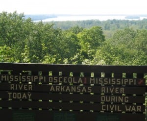
1. The Mississippi River is not the western boundary of Tennessee.
This one stumps people from all ages and all walks of life. It would seem that everyone in Tennessee is taught that the Mississippi River is the state’s western boundary.
It was at one time. After the Chickasaw Purchase of 1818, the Mississippi River became Tennessee’s western border. Since that time, however, the river has meandered so many times that in many places, the river is now miles from the state line.
This is why the site of Fort Pillow, a Civil War fort built on the river, is now landlocked. This is why two communities in Tipton County (Reverie and Corona) are west of the Mississippi River.
Because of the movement of the Mississippi River, there has been much confusion about where the boundary is. There was a time when lawbreakers hid out in the area because of confusion about the boundary. The U.S. Supreme Court has heard at least nine cases about the controversy.
So what’s the best way to explain it?
As I understand it, Tennessee’s boundary with Arkansas is where the channel of the Mississippi River was in 1836, when Arkansas became a state. Tennessee’s boundary with Missouri is where the channel of the Mississippi River was in 1821, when Missouri became a state.
2. Other than the eight states it borders, the state closest to Tennessee is …
About a year ago, my friend Robert Brandt asked me a question that threw me for a loop. He asked me which state was closest to Tennessee besides the eight it borders (Kentucky, Virginia, North Carolina, Georgia, Alabama, Mississippi, Arkansas and Missouri).
“That’s easy,” I said. “South Carolina.”
“Nope,” he said.
“Oh, I know! West Virginia!”
“Nope.”
Other than the eight states it borders, the next-closest to the Volunteer State is Illinois. It is a 46-mile drive from the Obion County community of South Fulton to Cairo, Ill.

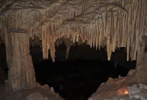
3. Tennessee has more caves than any other state.
Kentucky may have the best-known and the largest cave in the United States (that would be Mammoth Cave). But Tennessee has more than 8,000 documented caves — the most in the United States.
Most of these caves are either too small for people to enter or on private property with “no trespassing” signs posted in front of them. But there are some you are welcome to visit — like Cumberland Caverns in Warren County, Raccoon Mountain Caverns in Hamilton County, Tuckaleechee Caverns in Blount County and the Lost Sea in Monroe County.
4. Not all rivers in Tennessee flow into the Cumberland, Tennessee or Mississippi.
From one end of Tennessee to the other, every river eventually flows into either the Cumberland, Tennessee or Mississippi river — with one exception.
It is called the Conasauga River, and you will find it in southeast Tennessee, in Polk County. The Conasauga River starts in Georgia, flows northward into Tennessee and then comes back into Georgia, eventually merging with the Coosa River and Gulf of Mexico.

5. South Carolina is west of Tennessee
Surely, this can’t be true, can it? South Carolina lies along the Atlantic Ocean. Tennessee is an inland state, west of the big, long state of North Carolina.
Tennessee is west of South Carolina — right?
To be clear, most of South Carolina is east of Tennessee. However, parts of South Carolina are west of parts of Tennessee. If you look at a map, you can see that northeast Tennessee is farther east than the western parts of South Carolina.

In 1780, several hundred men from what is now northeast Tennessee met at the Sycamore Shoals of the Watauga River. They marched across the mountains in pursuit of a Tory army led by British Maj. Patrick Ferguson. They found Ferguson at a hill called Kings Mountain, defeated him and turned the tide of the American Revolution.
It is interesting to think that some of these men were actually moving (slightly) to the west!
6. Elevation-wise, Knoxville is lower than Cookeville, Kingsport, Erwin and Crossville.
People associate Knoxville with the nearby Great Smoky Mountains and with the University of Tennessee, an institution whose fight song is “Rocky Top.” Because of this, people often think that Knoxville’s elevation is higher than it really is.
Keep in mind that, like most cities, Knoxville is located on a river, so its elevation isn’t all that high.
Along the banks of the Tennessee River in Knoxville, the elevation is about 800 feet, and there are hilltops in Knoxville that rise higher than 1,000 feet. But compare this to the base elevations of Cookeville (1,140) Kingsport (1,208), Erwin (1,673) and Crossville (1,900).
7. The summertime temperature in Nashville is 5 degrees higher than the temperature in Crossville.
In the eastern part of the United States, people often think about temperature as a function of latitude (how far north you are). But temperature is also a function of altitude (how high you are).
Crossville has an elevation of about 1,900 feet, while Nashville’s is around 600 feet. Furthermore, Nashville is located in the bowl-shaped Central Basin of Tennessee. When there is a heat wave in the summer, the high temperature might be 98 in Nashville but only 93 in Crossville.
In fact, the average August temperature in Nashville is 89, but it is 84 in Crossville!
8. Tennessee has at least two meteor craters.
The larger of the two is the Wells Creek Crater near the juncture of Stewart, Houston and Montgomery counties. Scientists believe it was caused by a meteor strike that occurred between 100 million and 200 million years ago.
Once as deep as half a mile, today the Wells Creek Crater is not easily noticeable. In the 1860s, railroad crews digging in the area noticed strange rock formations that indicated that something unusual had happened in the area. Geologists began studying the area and eventually realized that the wide hole had been caused by a meteor.
Today, the Wells Creek Crater is known as the source of some of the best shatter cones in the world. “A shatter cone is a conical fragment of rock that is formed from the high pressure of a meteorite impact and has striations radiating from the apex of the cone,” says a newsletter of the Memphis Archaeological and Geological Society.
9. Memphis is much closer to Dallas, Texas, than to Mountain City, Tenn.
Length-wise, Tennessee is much larger than people realize.
It is 450 miles from Memphis to Dallas.
It is 550 miles from Memphis to Mountain City, which is the northeastern-most county seat in Tennessee.
(By the way, it is only 375 miles from Mountain City to Washington, D.C.)


